Mt Yotei · Routes
↘ Kimobetsu Route
This route carries serious backcountry hazards. Its slope and ATES labels are planning estimates; they do not decide whether it is safe today or suitable for your group.
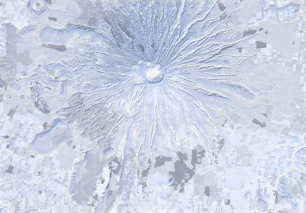 出典:国土地理院(標高タイル DEM10B を加工して作成)
Steepness · profile
← Distance 9.7 km →
Per-segment terrain (data table)
| % | m | Steepness | Aspect |
|---|---|---|---|
| 0% | 322 | 10° | N |
| 3% | 334 | 7° | NE |
| 6% | 357 | 7° | SE |
| 10% | 389 | 13° | SE |
| 13% | 427 | 14° | SE |
| 16% | 477 | 19° | SE |
| 19% | 519 | 23° | E |
| 23% | 580 | 21° | SE |
| 26% | 667 | 43° | E |
| 29% | 771 | 46° | E |
| 32% | 888 | 46° | NE |
| 35% | 1026 | 32° | E |
| 39% | 1167 | 34° | SE |
| 42% | 1325 | 41° | E |
| 45% | 1509 | 48° | E |
| 48% | 1695 | 45° | SE |
| 52% | 1884 | 46° | SW |
| 55% | 1781 | 48° | SE |
| 58% | 1587 | 41° | SE |
| 61% | 1391 | 41° | E |
| 65% | 1222 | 34° | SE |
| 68% | 1068 | 30° | E |
| 71% | 933 | 46° | E |
| 74% | 809 | 42° | E |
| 77% | 698 | 40° | SE |
| 81% | 605 | 18° | E |
| 84% | 535 | 23° | E |
| 87% | 486 | 14° | SE |
| 90% | 437 | 13° | SE |
| 94% | 397 | 7° | SE |
| 97% | 364 | 7° | SE |
| 100% | 338 | 6° | E |
Route guide
The Kimobetsu route climbs Yotei from its south-east flank — a long line of roughly 1,574 m of vertical that gains height almost continuously to just below the crater rim.
[~319 m — trailhead / start of forestry road] You set off from the parking area at the start of the forestry road and gain height gently along the road and firebreak. The lower grades are mellow and pleasant on a firm morning, but the trade-off is distance: this is a long approach.
[End of forestry road to ~700 m — the steep climb begins] Past the end of the forestry road the terrain stands up and you enter the section marked as the '700 m point (steep climb).' Above here the trees open toward treeline and the angle steepens. Skinning more directly banks height quickly, but it also means more time spent standing on avalanche terrain.
[Gully caution] Several gully features run down this south-east flank, and the track carries a point explicitly marked 'do not enter this gully.' It is easy to be drawn in when visibility is poor or when trying to avoid trail-breaking, but these drainages are collection points for windblown snow and any sliding snow — do not drop into them on a traverse or descent.
[~1,300 m — where most begin their descent] Above treeline the open, featureless cone characteristic of Yotei spreads out. This is the point flagged as '1,300 m — most descend from here,' and in practice many parties turn to ski from this elevation rather than pushing all the way to the top. The terrain above is steeper and far more exposed to wind and weather, so it is reasonable to treat 1,300 m as a decision point.
[~1,700 m and up — crampon / ski-crampon band] Above 1,300 m the snow trends toward crust, sastrugi and hard wind-deposit, and you enter the band noted as where 'crampons / ski-crampons may be required.' The measured maximum slope reaches about 50° in places, and the east-to-south-east aspect ices up readily after a cold night. When skins stop holding, switch to ski crampons early, and to booting / crampons if confidence drops further.
[~1,893–1,898 m — crater rim / summit] Topping out brings you to Yotei's summit ridge and crater rim (about 1,898 m), wrapped around the crater. The summit is unsheltered, the wind is extreme, and ground blizzard and whiteout are routine. The rim carries cornices and steep inner walls, so approach the edge with care.
[Descent — the most important caution] Yotei is an isolated cone, and high up, near-identical, featureless slopes fall away on every aspect. In flat light, cloud or ground blizzard it is easy to mistake the east-to-south-east face you climbed for an adjacent one and ski into a drainage on the wrong aspect. Do not skip checking your line against elevation (verify bearing by compass / GPS), and lose height deliberately — confirming the upper steeps, the gullies, and your entry into the trees below 1,300 m one step at a time. This is not a managed slope; the entire route is avalanche terrain.
Access & logistics
[Trailhead / parking] The line starts on the Kimobetsu (south-east) side at the forestry-road entrance, around 319 m. In winter the point you can drive to shifts with snow-clearing, so you typically park on a plowed shoulder or turnout — park so you do not block traffic or snow-clearing.
[Getting there] Approach is from the south-east, from the Kimobetsu side of Yotei. The start is a forestry-road entrance off the highway running up toward the mountain, but the end of the plowed road varies day to day in winter. Public transport is limited, so most parties arrive by private car or charter. Check current road and snow-clearing conditions before you go.
[Descent point] If you are not pushing to the summit, the '1,300 m' mark is the well-known point from which many parties begin their descent; weigh the upper steeps, ice and high wind there when deciding whether to turn around or continue.
[After] The towns around the base of Yotei — Niseko, Kutchan, Kimobetsu and others — have scattered onsen and places to eat. Opening days and hours vary by season, so confirm locally.
Yotei — local notes
- The summit dome is featureless — in a whiteout, navigate by compass bearing.
- The crater rim can be corniced — keep well back from the edge.
- Above ~1300 m the snow is often wind-hammered or icy — crampons or ski-crampons are commonly needed, and many parties descend from here.
- Near the summit the slope faces every aspect — wind-loading and sun change fast; read the bulletin’s full rose.
- On a symmetric cone with a featureless summit it’s easy to drop the wrong aspect in flat light and descend into a different valley than you climbed — confirm your descent bearing before dropping in.
Today / tomorrow briefing
Loading…
Set reminders inside Google Calendar
Hokkaido Wilds · Rob Thomson — HokkaidoWilds.org · CC BY-SA 4.0
A planning aid, not a verdict. Always check the day’s official avalanche bulletin and decide in the field.
山のまこちゃん · Video report
山のまこちゃん (Yama no Makochan) covers Yotei routes on video — embedding pending his permission.
Route data source: Rob Thomson — HokkaidoWilds.org · CC BY-SA 4.0 · ↓ Download GPX