Mt Yotei · Routes
↘ Kyogoku Route
This route carries serious backcountry hazards. Its slope and ATES labels are planning estimates; they do not decide whether it is safe today or suitable for your group.
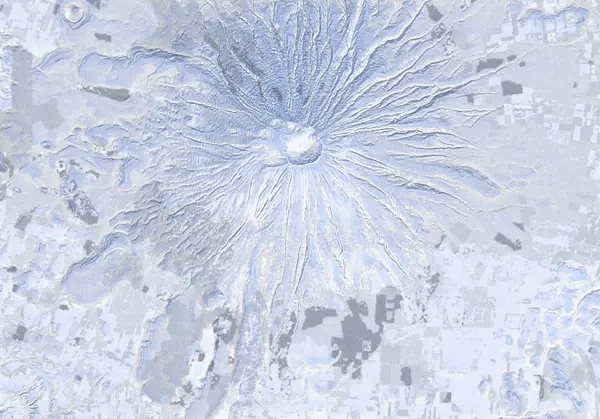 出典:国土地理院(標高タイル DEM10B を加工して作成)
Steepness · profile
← Distance 7.5 km →
Per-segment terrain (data table)
| % | m | Steepness | Aspect |
|---|---|---|---|
| 0% | 616 | 22° | NE |
| 3% | 678 | 38° | E |
| 6% | 743 | 32° | E |
| 10% | 815 | 33° | NE |
| 13% | 907 | 47° | NE |
| 16% | 1002 | 41° | N |
| 19% | 1117 | 34° | NE |
| 23% | 1245 | 40° | NE |
| 26% | 1386 | 44° | E |
| 29% | 1512 | 41° | E |
| 32% | 1626 | 39° | E |
| 35% | 1770 | 37° | E |
| 39% | 1883 | 46° | E |
| 42% | 1894 | 46° | NE |
| 45% | 1886 | 37° | E |
| 48% | 1765 | 39° | E |
| 52% | 1621 | 42° | E |
| 55% | 1508 | 44° | E |
| 58% | 1380 | 40° | E |
| 61% | 1240 | 34° | NE |
| 65% | 1111 | 43° | NE |
| 68% | 998 | 47° | N |
| 71% | 903 | 33° | NE |
| 74% | 812 | 32° | E |
| 77% | 744 | 38° | E |
| 81% | 680 | 22° | E |
| 84% | 619 | 20° | NE |
| 87% | 561 | 20° | NE |
| 90% | 516 | 10° | NE |
| 94% | 484 | 10° | NE |
| 97% | 459 | 16° | E |
| 100% | 433 | 28° | SE |
Route guide
The Kyogoku route climbs the northeast face of Mt Yotei (aspect NE–E, mean slope ~32°, max ~52°) from a trailhead at roughly 421 m to the summit zone near 1894 m — about 1473 m of vertical over ~8.1 km, alpine the whole way. It is classified as Complex (ATES Level 3) avalanche terrain; read this as a description of the ground and conditions, not as a recommendation.
[Trailhead ~421 m] Start at the trailhead sign. The lower track is gentle and sheltered in the forest, passing a 2nd road crossing early on; wind effect here is minimal.
[~970 m narrow spur] The ridge pinches to a narrow spur within the trees. The going is reasonably steady to here, but the angle steepens as you gain height.
[~1100–1350 m crampon zone] From around the 'Crampons/ski-crampons may be required' marker the surface firms up and wind-scoured ice becomes common. Skin grip can fail; ski crampons or boot crampons may be needed.
[~1350 m — 'Most descend from here'] This is the elevation widely used as a realistic turn-around and descent point. Above it the slope is wind-exposed, increasingly crusted and icy, and terrain becomes hard to read in poor visibility. Many parties turn here and ski the northeast face.
[Above ~1350 m — crater rim and summit] If continuing higher, expect sections reaching ~52°, harder snow, and strong wind on the ridge. Past Makkari-dake (1892 m) the route gains the crater rim and the summit of Yotei (1898 m; ~1894 m on the track). The top is a broad, near-featureless cone wrapped around a large crater.
[Descent caution] The main hazard is descending the wrong aspect. Yotei is a symmetrical, featureless cone with few reference points; in cloud or flat light it is easy to confuse the northeast face you climbed with an adjacent aspect and be drawn into a different gully or face. Descend while actively confirming your ascent aspect (NE–E) with GPS and compass. Watch for wind-loaded slab, weak layers under crust, and steep ground near the crater. This is avalanche terrain that demands judgement.
Access & logistics
[Trailhead & parking] The Kyogoku route starts on the northeast side of Yotei from the Kyogoku-side trailhead (~421 m, at the 'trailhead sign'). In winter, backcountry users self-park in the available pull-offs; plowing is variable and space is limited, so avoid blocking the road or snow-clearing operations.
[Getting there] Roughly 2–2.5 hours by car from Sapporo / New Chitose. Winter (studless) tyres are essential, and the forest road and approach may be unplowed. Public transport is sparse; a private car or an arranged tour is the practical option.
[Descent point] Because the upper mountain is wind-scoured and icy, many parties use the ~1350 m 'Most descend from here' point as a realistic turn-around and ski-down point.
[After] Day-use onsen and eateries are scattered around the Niseko / Kutchan / Kyogoku area. Confirm opening hours and winter closures yourself in advance.
Yotei — local notes
- The summit dome is featureless — in a whiteout, navigate by compass bearing.
- The crater rim can be corniced — keep well back from the edge.
- Above ~1300 m the snow is often wind-hammered or icy — crampons or ski-crampons are commonly needed, and many parties descend from here.
- Near the summit the slope faces every aspect — wind-loading and sun change fast; read the bulletin’s full rose.
- On a symmetric cone with a featureless summit it’s easy to drop the wrong aspect in flat light and descend into a different valley than you climbed — confirm your descent bearing before dropping in.
Today / tomorrow briefing
Loading…
Set reminders inside Google Calendar
Hokkaido Wilds · Rob Thomson — HokkaidoWilds.org · CC BY-SA 4.0
A planning aid, not a verdict. Always check the day’s official avalanche bulletin and decide in the field.
山のまこちゃん · Video report
山のまこちゃん (Yama no Makochan) covers Yotei routes on video — embedding pending his permission.
Route data source: Rob Thomson — HokkaidoWilds.org · CC BY-SA 4.0 · ↓ Download GPX